
Parcel 51-2N-25-015A-0081-0000
Owners
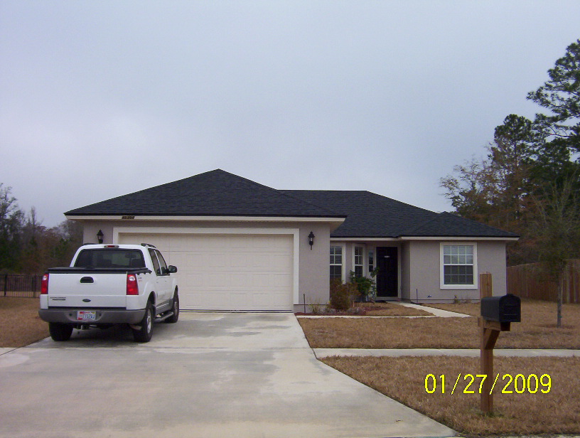
45358 INGLEHAM CR
CALLAHAN, FL 32011
Parcel Summary
| Situs Address | 45358 INGLEHAM CIR |
|---|---|
| Use Code | 0100: SINGLE FAMILY |
| Tax District | 1: Callahan |
| Acreage | 0.000 |
| Section | 51 |
| Township | 2N |
| Range | 25 |
| Subdivision | AMHURST OAKS |
| Exemptions | HX: Homestead (196.031(1)(a)) (100%) HB: Homestead Banded (196.031(1)(ab) (100%) |
Short Legal
LOT 81IN OR 1953/370
AMHURST OAKS PB 7/180
Values
| 2025 Certified Values | 2026 Preliminary Values | |
|---|---|---|
| Land Value * | $40,000 | $41,000 |
| (+) Improved Value | $231,927 | $220,587 |
| (=) Market Value | $271,927 | $261,587 |
| (-) Agricultural Classification | $0 | $0 |
| (-) SOH or Non-Hx* Capped Savings ** | $118,816 | $104,342 |
| (=) School Assessed Value | $153,111 | $182,245 |
| County Assessed Value | $153,111 | $157,245 |
| (-) School Exemptions | $25,000 | $50,000 |
| (-) Non-school Exemptions | $50,722 | $51,411 |
| (=) School Taxable Value *** | $128,111 | $132,245 |
| (=) County Taxable Value | $102,389 | $105,834 |
Document/Transfer/Sales History
| Instrument / Official Record | Date | Q/U | V/I | Sale Price | Grantor | Grantee |
|---|---|---|---|---|---|---|
| WD 1953/0370 | 2014-12-12 | U | Improved | $101,500 | CATRETT CHRISTOPHER & TAYLOR | MANGUM NICOLE S & WAYNE L |
| WD 1790/1631 | 2012-04-26 | Q | Improved | $104,000 | FANNIE MAE | CATRETT CHRISTOPHER |
| CT 1769/1569 | 2011-12-19 | U | Improved | $100 | CLERK OF COURT | FEDERAL NATIONAL MORTGAGE ASSOCIATION |
| WD 1543/1854 | 2008-01-02 | U | Improved | $171,300 | TOUSA HOMES INC | COTE STEVEN A |
| WD 1438/1860 | 2006-08-23 | U | Vacant | $4,230,000 | AMHURST OAKS LLC | TOUSA HOMES INC |
Buildings
Building # 1
| Heated Sq Ft | Year Built | Value |
|---|---|---|
| 1519 | 2007 | $220,587 |
Structural Elements
| Type | Description | Code | Details |
|---|---|---|---|
| EW | Exterior Wall | 31 | HARDIE BRD |
| EW | Exterior Wall | 16 | WD FR STUC |
| RS | Roof Structure | 03 | GABLE/HIP |
| RC | Roof Cover | 03 | COMP SHNGL |
| IW | Interior Wall | 05 | DRYWALL |
| IF | Interior Flooring | 14 | CARPET |
| IF | Interior Flooring | 11 | CLAY TILE |
| AC | Air Conditioning | 03 | CENTRAL |
| HT | Heating Type | 04 | AIR DUCTED |
| BDR | Bedrooms | 3.00 | |
| BTH | Bathrooms | 2.00 | |
| FR | Frame | 02 | WOOD FRAME |
| STR | Stories | 1. | 1. |
Land Lines
Personal Property
None
TRIM Notices
Property Record Cards
Disclaimer
The Nassau County Property Appraiser's Office makes every effort to produce the most accurate information possible. No warranties, expressed or implied, are provided for the data herein, its use or interpretation. The information contained herein is for ad valorem tax assessment purposes only. The Property Appraiser exercises strict auditing procedures to ensure validity of any transaction received and posted by this office but cannot be responsible for errors or omissions in the information received from external sources. Due to the elapsed time between transactions in the marketplace, and the time that those transactions are received from the public and/or other jurisdictions, some transactions will not be reflected.